I see what you're saying but didn't they crash above sea level, so they should be the same?Could be the difference between above ground and above sea level altitudes.
You are using an out of date browser. It may not display this or other websites correctly.
You should upgrade or use an alternative browser.
You should upgrade or use an alternative browser.
The future of flying
- Thread starter Uncle Cr33pin
- Start date
Could be the difference between above ground and above sea level altitudes.
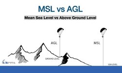
No. You have an altimeter which (should) always be set to reflect sea level altitude and then you have ground proximity level ie how far you're from the actual terrain.
The black hawk was 100ft too high from the terrain but just kept its trajectory.
2 different metrics:I see what you're saying but didn't they crash above sea level, so they should be the same?

I was thinking that maybe the pilot (-ess) was reading the wrong gauge, and thought she's lower than she really was.No. You have an altimeter which (should) always be set to reflect sea level altitude and then you have ground proximity level ie how far you're from the actual terrain.
The black hawk was 100ft too high from the terrain but just kept its trajectory.
I understand you diagram, but they were over the sea when they collided, so AGL and MSL should be the same.2 different metrics:
View attachment 17569
I was thinking that maybe the pilot (-ess) was reading the wrong gauge, and thought she's lower than she really was.
Iakobos
Orthodox
Pilots don't use AGL during most operations so it's not really relevant here. It's possible the helo pilots had their altimeter set incorrectly (it has to be compensated for local air pressure conditions to display true elevation), that would be a giga-rookie mistake but stranger things have happened.
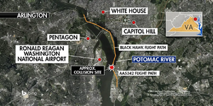
Look at that image.Nope. It happened almost in the middle of Washington DC.
View attachment 17577
They crashed over the Potomac river, which feeds into Chesapeake Bay, which leads in the Atlantic ocean - sea level. When they collided the AGL and MSL should be the same.
Look at that image.
They crashed over the Potomac river, which feeds into Chesapeake Bay, which leads in the Atlantic ocean - sea level. When they collided the AGL and MSL should be the same.
Think there still would be a difference in elevation.
But it doesn't seem to be relevant, as explained:
Pilots don't use AGL during most operations so it's not really relevant here. It's possible the helo pilots had their altimeter set incorrectly (it has to be compensated for local air pressure conditions to display true elevation), that would be a giga-rookie mistake but stranger things have happened.
Pilots don't use AGL during most operations so it's not really relevant here. It's possible the helo pilots had their altimeter set incorrectly (it has to be compensated for local air pressure conditions to display true elevation), that would be a giga-rookie mistake but stranger things have happened.
*Edit
There wouldn't be any AGL warnings as they were above a river that's at sea level thanks @homersheineken
So what I can gather is that the visual the heli pilots had were not from the jet they collided with but with the one behind it who didn't need to deviate to runway 33.
What a military helicopter was even doing there crossing the approach of a runway of an extremely busy commercial airport is another story.
Last edited:
I thought the Potomac River would above sea level where it passes through Washington DC, but I just checked, and you are right. The river surface by the airport is zero meters above sea level.I understand you diagram, but they were over the sea when they collided, so AGL and MSL should be the same.
Last edited:
I thought the Potomac River would above sea level where it passes through Washington DC, but I just checked, and you are right. The river surface by the airport is zero meters above sea level.
I've made the same assumption.
@homersheineken - You were right.


This may be an odd question, and I don't want to derail the thread (so please let me know if I need to move it or make a new thread), but what is the legality of the TSA having TSAPre for people who can pay for it?
Is it me, or does this create some kind of Constitutional violation? I believe the TSA as a whole is a misstep on the Bill of Rights (Amendment IV: The right of the people to be secure in their persons, houses, papers, and effects, against unreasonable searches and seizures, shall not be violated, and no warrants shall issue, but upon probable cause, supported by oath or affirmation, and particularly describing the place to be searched, and the persons or things to be seized).
How do they justify allowing a segment of the populace to pay a fee and reduce their wait times by skipping out on what the normal lines require (taking shoes off, etc.)? Doesn't this create a caste system of travelers (those who can pay and those who can't)? And is it technically illegal for the government to do so, since we all pay for the TSA anyway?
I've always wondered if there is potential for a massive discrimination lawsuit here.
Negative.Would anyone here fly internationally now with your kids on board? Serious question.
I've been to SEA 15 times in the past 8 years, a couple of times with my kids, and my wife wants to travel again.
I have made it clear that I have no desire to leave the US ever again.
And my kids aren't traveling anywhere without me.
I don't have kids, so it's a hypothetic question for me. However, I will continue to fly. I think the odds of an aircraft accident are still very low. I will also continue to drive my car, which has its own risks.Would anyone here fly internationally now with your kids on board? Serious question.
I don't have kids, so it's a hypothetic question for me. However, I will continue to fly. I think the odds of an aircraft accident are still very low. I will also continue to drive my car, which has its own risks.
Thing is if there's something wrong with my car most of the time I can pull over, I'm also the pilot of the car so when I have my whole family in the thing it makes me more devoted to their safety rather than some airline / safety committee.
Not sure, I've been planning this trip for years finally got the funds together and now these planes are falling out of the skies.
My wife thinks my faith isn't strong enough, women can be right sometimes.
This involves faith in other human beings, not faith in God.
My take on all of this:
Now might be the last time for several years to fly.
This is because the pilot pipeline takes years of training. The last remaining decent pilots are still in the air, but under them is a wave of DEI shit-for-brains coming up.
The DEI folks will be pushed out by the end of the Trump admin, and replaced with good pilots again. But those good pilots are just going to start this year. It takes around 10K hours to train a good airline pilot. So the new guys starting today might not be ready for another 3 years.
I'd say from within the next 3 months are barely safe, and then avoid for about 3 years, and things will be good again.
Went down Feb 06, witnesses reported seeing smoke before it crash landed.

