Cosmology Debate Thread ("Space Is Fake")

@MusicForThePiano Nice post. I vouch for the expansive thinking.

Though I think the "flat earth" is just a distractionary narrative.

From the mere fact that the sunrise, sunsets work like a perfect model of the earth and light / heat (sun) moving around it. As if the earth is a ball.

I guess i'm most open to the idea the earth is the center of Gods creation and the light moves around it.

What triggers me is that we have no clue what's in the earth. We went at max 10km deep. And there is no organized exploration deeper. They say it's a big lava ball. That seems nonsense to me.

Also I am surprised we have barely explored the "south pole". Why's that?

We have to believe faker Elon goes to Mars, but we can not explore the south pole and deeper than 10km.

I think we have never went higher than 10-20km, never deeper than 10km and some parts are unexplored.

I think we have actually no clue what is going on, I think we might not be able to comprehend it, I have a much more poetic vision of the world and around it.

just as we can't photograph and atom (it's just a model), we can't know the universe.

I feel the Psalms might the best way to undnerstand or ununderstand the creation.
 
I used to think people in the Middle ages believed that the earth was flat and Columbus first discovered it was round. But that was a lie they taught us in high school, most likely to discredit Christianity and make us look backward. The textbooks depict Columbus as some sort of enlightened, rational hero fighting against the ignorance of the church and the monarchs that were stopping him from sailing. But in reality, any educated person in the Middle ages and back to ancient Greece knew the earth is round.

The fact that so many of these countries got big into maritime travel and specifically with sailing west in order to find a path to India/Far East is a pretty good indication that it was well known among people that the earth was a globe. If they had assumed a flat earth then it seems like they wouldn't have bothered sailing west in order to reach Indian, East Asia etc. These expeditions were launched with the assumption that by going west they would be able eventually reach a location that previously had only been reached by going east from their origin.
 
The fact that so many of these countries got big into maritime travel and specifically with sailing west in order to find a path to India/Far East is a pretty good indication that it was well known among people that the earth was a globe. If they had assumed a flat earth then it seems like they wouldn't have bothered sailing west in order to reach Indian, East Asia etc. These expeditions were launched with the assumption that by going west they would be able eventually reach a location that previously had only been reached by going east from their origin.
In middle school our teacher told us Columbus's sailors did not believe in a round earth and were afraid they would fall off the edge of the world 😂
 
To be fair you can reach Asia just the same travelling west on a flat earth map.
Meaning a globe earth is not required to travel west from Europe to get to Asia.

81XJGnGyaAL.jpg
 
The fact that so many of these countries got big into maritime travel and specifically with sailing west in order to find a path to India/Far East is a pretty good indication that it was well known among people that the earth was a globe. If they had assumed a flat earth then it seems like they wouldn't have bothered sailing west in order to reach Indian, East Asia etc. These expeditions were launched with the assumption that by going west they would be able eventually reach a location that previously had only been reached by going east from their origin.

What I am reading..
Where did you get the info that say Britain was definitely sailing West to to reach India or East Asia?
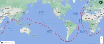
Below, a drawing for what means to sail 'West' to those regions on a Globe map versus South via West Africa, South Africa, Madagascar and finally India on the same map... What do you see? Of course no Panama sailing through or Suez canal/HoA, just the old fashioned way..

The info that they were sailing West to reach Asia is bonkers imo.
Now if you look at the Gleason map above you'll see that it was much better to sail via Africa towards Asia, then the Suez canal was dug.


1710621837197.png
 
What I am reading..
Where did you get the info that say Britain was definitely sailing West to to reach India or East Asia?
Below, a drawing for what means to sail 'West' to those regions on a Globe map versus South via West Africa, South Africa, Madagascar and finally India on the same map... What do you see? Of course no Panama sailing through or Suez canal/HoA, just the old fashioned way..

The info that they were sailing West to reach Asia is bonkers imo.
Now if you look at the Gleason map above you'll see that it was much better to sail via Africa towards Asia, then the Suez canal was dug.


View attachment 6281

Columbus' voyages (which is what is being referred to and not the British voyages that came later and were just following the paths already set by the Spaniards) were sponsored by King Ferdinand and Queen Isabella of Spain with the understanding that the point the expeditions was to find a westward route to Asia. Europeans has already reached Asia through eastern land routes but those were closed off with the fall of the Byzantines and the rise of the Ottomans. The Portuguese had won control of the west coast of Africa after the War of the Castilian Succession which meant they had control of the eastern route to Asia that goes along the African coast that you pointed out. This motivated the Spanish monarchy to invest in these westward voyages to find a route that wouldn't have to go through Ottoman or Portuguese spheres of influence.

Here is Columbus' journal of his first voyage
Notice on the second page he wrote that was undertaking this voyage because he was "ordered that I should not go by land eastward as has been customary , but that I should go by way of the west, whither up to this day, we do not know for certain that any one has gone"
 
To be fair you can reach Asia just the same travelling west on a flat earth map.
Meaning a globe earth is not required to travel west from Europe to get to Asia.

81XJGnGyaAL.jpg

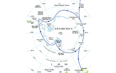
Does that map represent one of the level earth models? It seems that if it were then traveling along the boundary of Antartica would be the maximum route.

There have been recent circumnavigations of Antartica. The people doing it seem like more or less normal people (yacht enthusiasts) and not government or corporate backed.

Here was their route. It took them 100 days:


Edit: They were tied to the International Scientific ARGO Program
 

Attachments

  • 9739BA4B-247D-4733-85AD-3CBD981AA799.webp
    9739BA4B-247D-4733-85AD-3CBD981AA799.webp
    300.2 KB · Views: 43
Last edited:
@paternos and @Cooper and anyone else who is adamant about the heliocentric model. The proper term would be "level plane" earth, not "flat". Also no one has offered anything for proof of the existence of spatial curvature on the horizon. The windmill example can be easily disproved for what we are seeing, as I will explain below. Many people are confusing the horizon to be an objective state of reality, whereas the earth as the foundation of the universe, is near infinite in its space. We do not know its boundaries, and we cannot leave this earth. The horizon that we see with our own eyes is a subjective optical phenomena.

Would you be able to go more into detail about this - specifically the part about how earth is near infinite in it's space. If someone were to keep traveling in one direction continuously does this mean that the person would just keep moving indefinitely? If not, what point would the person eventually reach?
 
To be fair you can reach Asia just the same travelling west on a flat earth map.
Meaning a globe earth is not required to travel west from Europe to get to Asia.

81XJGnGyaAL.jpg
For us to see if this map is accurate we would have to study uses of it in real world scenarios - namely those involving traveling around the world. Would you be able to provide some examples of say ship navigators or airplane pilots using the model depicted in this map in order to ensure that they arrived in the location they are trying to reach?

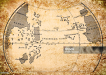
I'll go first in showing the a map that assumed a global earth that was used in a real world situation. Since I was talking about Columbus' western voyages to reach Asia above, I'll show the map that he based his travels on, designed by Paolo dal Pozzo Toscanelli.

istockphoto-899657636-2048x2048.jpg

As you can see from the map, it was assumed that China (called Kathai on this map) and India could be reached via sailing westward. The Americas weren't known by Europeans at the time which is why you don't see it between Asia and Europe on this map. It's also why Columbus initially thought he had reached India when he first landed in the Americas. As I showed above, Columbus had written that he was traveling west from Europe with the assumption he would eventually end up in Asia since he had assumed a global earth. If he had been traveling using a map that was like the Gleason flat earth map then surely his writings on his voyage would be different than what they are.
 
Last edited:
For us to see if this map is accurate we would have to study uses of it in real world scenarios - namely those involving traveling around the world. Would you be able to provide some examples of say ship navigators or airplane pilots using the model depicted in this map in order to ensure that they arrived in the location they are trying to reach?

I'll go first in showing the a map that assumed a global earth that was used in a real world situation. Since I was talking about Columbus' western voyages to reach Asia above, I'll show the map that he based his travels on, designed by Paolo dal Pozzo Toscanelli.

View attachment 6303

As you can see from the map, it was assumed that China (called Kathai on this map) and India could be reached via sailing westward. The Americas weren't known by Europeans at the time which is why you don't see it between Asia and Europe on this map. It's also why Columbus initially thought he had reached India when he first landed in the Americas. As I showed above, Columbus had written that he was traveling west from Europe with the assumption he would eventually end up in Asia since he had assumed a global earth. If he had been traveling using a map that was like the Gleason flat earth map then surely his writings on his voyage would be different than what they are.
I thought everyone knew this. Noone knew about the Americas till Columbus bumped into it. Isnt that why the Caribbean is known as the West Indies?
 
I thought everyone knew this. Noone knew about the Americas till Columbus bumped into it. Isnt that why the Caribbean is known as the West Indies?
Even that statement is a cause of controversy. It's a good excuse to make some noise though:

 
Globers don't even understand their giant far away sun requires parallel rays yet we see crepescular rays but wait for the magic handwave 'muh refraction'.
Is this guy a troll or does he sincerely believe the flat earth nonsense?

Have flat earthers never been on a plane and seen that the earth is curved?
 
Last edited:
Having threads about nonsensical ignorant topics makes the forum look like it is full of ignorant crackpots and dissuades new people from joining the forum.

So the threads about jews controlling the world, satanic pedofiles running hollywood, and covid being a psyop are all ok....but this is the thread that's gonna make potential new members go elesewhere ??
 
Having threads about nonsensical ignorant topics makes the forum look like it is full of ignorant crackpots and dissuades new people from joining the forum.

That's the whole idea.

There's a reason why Roosh didn't allow any of these discussions, because they're only here to disrupt the real conversations we're having or might be having instead we argue about lunacy like flat earth.

It's funny how these flat earth people seemingly transition from "yo bro you're stupid for not understanding us' to bringing up vantage points we all use if you have any idea of drawing and which has never been used to debunk the earth being a sphere until recently (by them).
Pilots don't use a 'flat earth' schematic, I can guarantee you that or we wouldn't have international flights.

I can't be F'd as they say.

Incoming...
 
Last edited:
Is this guy a troll or does he sincerely believe the flat earth nonsense?

Have flat earthers never been on a plane and seen that the earth is curved?

Again like I stated don’t even bother to engage them and these trolls will be gone in a few months. I have every one of these nonsense posters on ignore so all I see are the posts where you guys continue to try to convince them. I’m thinking some of the accounts here are part of the scheme using a good cop, bad cop, dialectic routine, so I’ll just ignore the other guys responding too.

They are trolls probably from a troll farm overseas and full of utter crap.
 
No denying reality
1,000 years ago, Persian scientist Al-Burini was able to estimate the radius of Earth within a 99% accuracy by using trigonometry:


Anyone can replicate that experiment.

Also, why can't you even see the sun after sunset in NYC when it's still high up above "pizza earth" only 3 time zones away on the west coast??

Key word: "estimate"

Not measure

Because again based on assumptions. I don't currently have time to type this out but please watch these 2 very short videos if you are truly curious about yet another mystical glober getting torn to shreds:


Shorter version:

 
Back
Top